Ficheiro:Continental-drift-1858.jpg
De CriaçãoWiki, a enciclopédia da ciência da criação.
Saltar para a navegaçãoSaltar para a pesquisa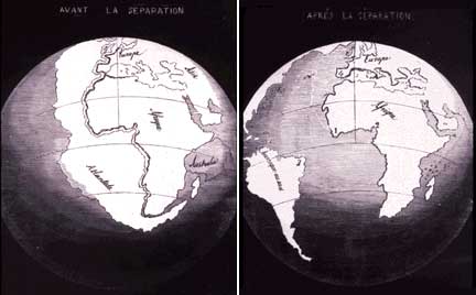
Sem resolução maior disponível.
Continental-drift-1858.jpg (432 × 268 píxeis, tamanho: 16 kB, tipo MIME: image/jpeg)
Histórico do ficheiro
Clique uma data e hora para ver o ficheiro tal como ele se encontrava nessa altura.
| Data e hora | Miniatura | Dimensões | Utilizador | Comentário | |
|---|---|---|---|---|---|
| atual | 22h45min de 28 de novembro de 2008 | | 432 × 268 (16 kB) | Ashcraft | In 1858, geographer Antonio Snider-Pellegrini made these two maps showing his version of how the American and African continents may once have fit together, then later separated. Left: The formerly joined continents before (avant) their separation. Right: |
Utilização local do ficheiro
As seguintes 2 páginas usam este ficheiro: