File:Precambria continents.jpg
Precambria_continents.jpg (336 × 355 pixels, file size: 71 KB, MIME type: image/jpeg)
Summary
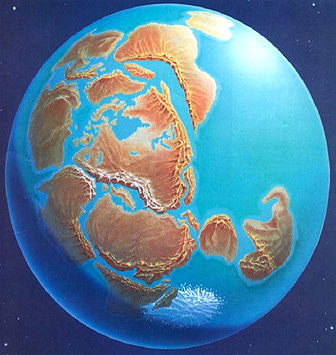
According to NASA - "This figure below depicts a hypothetical early Earth distribution of protocontinents which drifted by seafloor spreading until they collided into a supercontinent (Rondinia); that single supercontinent then broke up (like the later Pangaea) and its fragments made new individual continents - this process of coming together, splitting, moving in various directions over the global surface, recombining, resplitting, etc. probably has happened at least several times in Earth history."
Copyright status
This image is public domain because it was first published by the National Aeronautics and Space Administration.
Source
This image is from the NASA Remote Sensing Tutorial
File history
Click on a date/time to view the file as it appeared at that time.
| Date/Time | Thumbnail | Dimensions | User | Comment | |
|---|---|---|---|---|---|
| current | 07:24, 1 December 2008 | | 336 × 355 (71 KB) | TaeWoong (talk | contribs) | One suggested configuration of continental blocks at some stage during the Precambrian |
You cannot overwrite this file.
File usage
There are no pages that use this file.