File:Opium map.png
Opium_map.png (466 × 330 pixels, file size: 46 KB, MIME type: image/png)
Summary
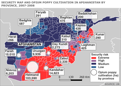
Description English: Map of Afghanistan showing the security situation by district and opium cultivation by province in the period 2007 to 2008. Date 2008 Source http://news.bbc.co.uk/2/hi/south_asia/7663204.stm Author United Nations Department of Safety and Security
Copyright status:
This military map image could be recreated using vector graphics as an SVG file. This has several advantages; see Commons:Media for cleanup for more information. If an SVG form of this image is available, please upload it and afterwards replace this template with Template:Vector version available.
Source:
File history
Click on a date/time to view the file as it appeared at that time.
| Date/Time | Thumbnail | Dimensions | User | Comment | |
|---|---|---|---|---|---|
| current | 18:38, 22 May 2016 | | 466 × 330 (46 KB) | Sarah.yosef (talk | contribs) | Description English: Map of Afghanistan showing the security situation by district and opium cultivation by province in the period 2007 to 2008. Date 2008 Source http://news.bbc.co.uk/2/hi/south_asia/7663204.stm Author United Nations Department of Saf... |
You cannot overwrite this file.
File usage
There are no pages that use this file.