File:Galapagos-satellite-photo.jpg
Galapagos-satellite-photo.jpg (800 × 600 pixels, file size: 79 KB, MIME type: image/jpeg)
Summary
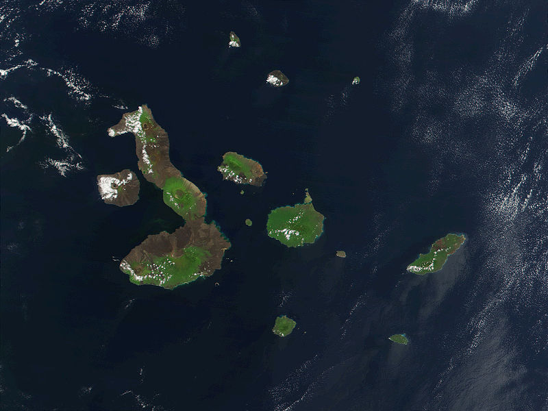
Description English: This true-color image of the Galapagos Islands was acquired on March 12, 2002, by the Moderate-resolution Imaging Spectroradiometer (MODIS), flying aboard NASA's Terra satellite. The Galapagos Islands, which are part of Ecuador, sit in the Pacific Ocean about 1000 km (620 miles) west of South America. As the three craters on the largest island (Isabela Island) suggest, the archipelago was created by volcanic eruptions, which took place millions of years ago. Date 12 March 2002 Source Earth Observatory 8270 and NASA GSFC Author Jacques Descloitres, MODIS Rapid Response Project at NASA/GSFC
Copyright status:
This file is in the public domain because it was solely created by NASA. NASA copyright policy states that "NASA material is not protected by copyright unless noted". (See NASA copyright policy page or JPL Image Use Policy.) |
|||
| Warnings: •Use of NASA logos, insignia and emblems are restricted per US law 14 CFR 1221. | |||
Source:
http://commons.wikimedia.org/wiki/File:Galapagos-satellite-2002.jpg
File history
Click on a date/time to view the file as it appeared at that time.
| Date/Time | Thumbnail | Dimensions | User | Comment | |
|---|---|---|---|---|---|
| current | 00:42, 23 February 2014 | | 800 × 600 (79 KB) | Luiz Alexandre Silva (talk | contribs) | Description English: This true-color image of the Galapagos Islands was acquired on March 12, 2002, by the Moderate-resolution Imaging Spectroradiometer (MODIS), flying aboard NASA's Terra satellite. The Galapagos Islands, which are part of Ecuador, sit |
You cannot overwrite this file.
File usage
There are no pages that use this file.