File:Continental-drift-1858.jpg
Continental-drift-1858.jpg (432 × 268 pixels, file size: 16 KB, MIME type: image/jpeg)
Summary
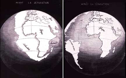
In 1858, geographer Antonio Snider-Pellegrini made these two maps showing his version of how the American and African continents may once have fit together, then later separated. Left: The formerly joined continents before (avant) their separation. Right: The continents after (aprés) the separation. (Reproductions of the original maps courtesy of University of California, Berkeley.)
Copyright status
This image is in the public domain because its copyright has expired. This applies to the United States, Canada, the European Union and those countries with a copyright term of life of the author plus 70 years.
Source
File history
Click on a date/time to view the file as it appeared at that time.
| Date/Time | Thumbnail | Dimensions | User | Comment | |
|---|---|---|---|---|---|
| current | 22:45, 28 November 2008 | | 432 × 268 (16 KB) | Ashcraft (talk | contribs) | In 1858, geographer Antonio Snider-Pellegrini made these two maps showing his version of how the American and African continents may once have fit together, then later separated. Left: The formerly joined continents before (avant) their separation. Right: |
You cannot overwrite this file.
File usage
There are no pages that use this file.