File:Bitis-arietans-range-map.png
Bitis-arietans-range-map.png (358 × 390 pixels, file size: 13 KB, MIME type: image/png)
Summary
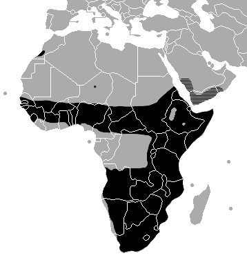
Geographic range of Bitis arietans. The distribution (black area) on the African continent is based on the map provided by Spawls & Branch (1995). The black dot in Niger reflects an actual locality record in an area where the distribution is poorly understood (also Spawls & Branch, 1995). The hatched area in the Arabian peninsula is inferred from the geographic description given by McDiarmid et al. (1999), reports that the species exists in Oman (EMBL, Oman Times), and the extent of the Rub' al Khali desert.
Copyright status
this picture is public domain because it was found on Wikimedia Commons
Source
http://en.wikipedia.org/wiki/Image:Bitis-arietans-range-map.png
File history
Click on a date/time to view the file as it appeared at that time.
| Date/Time | Thumbnail | Dimensions | User | Comment | |
|---|---|---|---|---|---|
| current | 15:11, 4 January 2008 | | 358 × 390 (13 KB) | Lwashio (talk | contribs) | Geographic range of Bitis arietans. The distribution (black area) on the African continent is based on the map provided by Spawls & Branch (1995). The black dot in Niger reflects an actual locality record in an area where the distribution is poorly unders |
You cannot overwrite this file.
File usage
There are no pages that use this file.