Ficheiro:Midoceanic ridge topography.gif
De CriaçãoWiki, a enciclopédia da ciência da criação.
Saltar para a navegaçãoSaltar para a pesquisa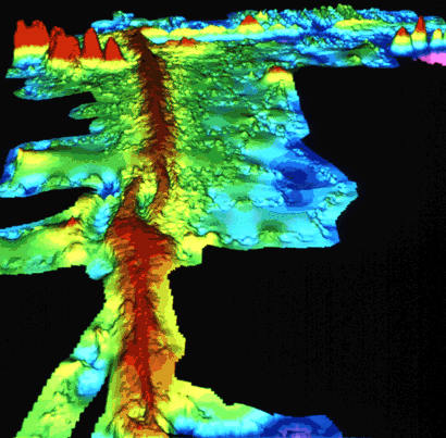
Sem resolução maior disponível.
Midoceanic_ridge_topography.gif (410 × 403 píxeis, tamanho: 55 kB, tipo MIME: image/gif)
Summary
Source: USGS (public domain) http://pubs.usgs.gov/publications/text/topomap.html
Computer-generated detailed topographic map of a segment of the Mid-Oceanic Ridge. "Warm" colors (yellow to red) indicate the ridge rising above the seafloor, and the "cool" colors (green to blue) represent lower elevations. This image (at latitude 9° north) is of a small part of the East Pacific Rise. (Imagery courtesy of Stacey Tighe, University of Rhode Island.)
Copyright status:
| This image is in the public domain because it contains materials that originally came from the United States Geological Survey, an agency of the United States Department of the Interior. For more information, see the official USGS copyright policy. |
Source:
Histórico do ficheiro
Clique uma data e hora para ver o ficheiro tal como ele se encontrava nessa altura.
| Data e hora | Miniatura | Dimensões | Utilizador | Comentário | |
|---|---|---|---|---|---|
| atual | 23h21min de 20 de setembro de 2013 | | 410 × 403 (55 kB) | Luiz Alexandre Silva | Source: USGS (public domain) http://pubs.usgs.gov/publications/text/topomap.html Computer-generated detailed topographic map of a segment of the Mid-Oceanic Ridge. "Warm" colors (yellow to red) indicate the ridge rising above the seafloor, and the "cool" |
Utilização local do ficheiro
A seguinte página usa este ficheiro: