File:UN Partition Plan For Palestine 1947.png
UN_Partition_Plan_For_Palestine_1947.png (327 × 598 pixels, file size: 71 KB, MIME type: image/png)
Summary
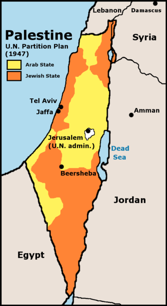
Map showing the 1947 UN partition plan for Palestine
Copyright status
Copyright: GFDL derivative work created by the uploader based on a portion of the public domain work http://www.lib.utexas.edu/maps/historical/israel_hist_1973.jpg . At http://www.lib.utexas.edu/maps/faq.html that site states that "Most of the maps scanned by the General Libraries and served from this web site are in the public domain. No permissions are needed to copy them. You may download them and use them as you wish. A few maps are copyrighted, and are clearly marked as such". There is no such mark with this map, so it is presumed to have been in the public domain before the derivative work was created. The uploader hereby releases the derivative work under the GFDL.
Source
http://en.wikipedia.org/wiki/Image:UN_Partition_Plan_For_Palestine_1947.png
File history
Click on a date/time to view the file as it appeared at that time.
| Date/Time | Thumbnail | Dimensions | User | Comment | |
|---|---|---|---|---|---|
| current | 00:30, 5 December 2006 | | 327 × 598 (71 KB) | Ashcraft (talk | contribs) | Map showing the 1947 UN partition plan for Palestine |
You cannot overwrite this file.
File usage
There are no pages that use this file.