File:Mount St. Helens eruption.jpg
Original file (400 × 603 pixels, file size: 57 KB, MIME type: image/jpeg)
Summary
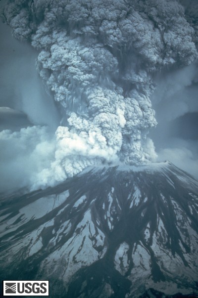
On May 18, 1980, at 8:32 a.m. Pacific Daylight Time, a magnitude 5.1 earthquake shook Mount St. Helens. The bulge and surrounding area slid away in a gigantic rockslide and debris avalanche, releasing pressure, and triggering a major pumice and ash eruption of the volcano. Thirteen-hundred feet (400 meters) of the peak collapsed or blew outwards. As a result, 24 square miles (62 square kilometers) of valley was filled by a debris avalanche, 250 square miles (650 square kilometers) of recreation, timber, and private lands were damaged by a lateral blast, and an estimated 200 million cubic yards (150 million cubic meters) of material was deposited directly by lahars (volcanic mudflows) into the river channels. Fifty-seven people were killed or are still missing.
USGS Photograph taken on May 18, 1980, by Austin Post.
Larger version available. http://vulcan.wr.usgs.gov/Imgs/Jpg/MSH/Images/MSH80_eruption_mount_st_helens_05-18-80.jpg
Copyright status:
This image is public domain because it was first published by the U.S. Geological Survey
Source:
http://vulcan.wr.usgs.gov/Volcanoes/MSH/Publications/MSHPPF/MSH_past_present_future.html
File history
Click on a date/time to view the file as it appeared at that time.
| Date/Time | Thumbnail | Dimensions | User | Comment | |
|---|---|---|---|---|---|
| current | 21:20, 17 April 2009 | | 400 × 603 (57 KB) | Ashcraft (talk | contribs) |
You cannot overwrite this file.
File usage
There are no pages that use this file.