No higher resolution available.

|
This image was uploaded to the shared "Image Pool" and is usable on any CreationWiki site.
Please go to the Pool to edit its description.
|
Summary
Artist
John Pinkerton (1758–1826) Link back to Creator infobox template
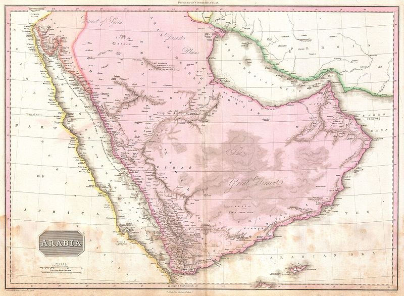
Title Arabia.
Description
English: Extraordinary large format map of Arabia published in 1818 by cartographer John Pinkerton. Centered on the desert province of Neged, this map details the entire Arabian peninsula as well as the Red Sea, the Persian Gulf, and adjacent parts of Africa and Persia. Covers the modern day countries of Saudi Arabia, Yemen, Oman, United Arab Emirates, Qatar and Kuwait. Pinkerton offers extraordinary detail throughout noting both physical and political details. When this map was made the interior of Arabia was little known in European circles. Most of the cartographic material used to compose this map comes from older sources and from the ill fated expedition of the Danish explorer Carsten Neibuhr. Neibuhr was the sole survivor of one of the few European expeditions to this region in the 18th century. His work had a profound influence on the cartography of this region for some 200 years. This is undoubtedly one the most attractive and influential maps of the Arabian peninsula to appear in the 19th century. Drawn by L. Herbert and engraved by Samuel Neele under the direction of John Pinkerton. The map comes from the scarce American edition of Pinkerton’s Modern Atlas, published by Thomas Dobson & Co. of Philadelphia in 1818.
Date 1818 (undated)
Dimensions Height: 21 in (53.3 cm). Width: 28 in (71.1 cm).
Accession number Geographicus code: Arabia2-pinkerton-1818
Source/Photographer
Pinkerton, J., A Modern Atlas, from the Lates and Best Authorities, Exhibiting the Various Divisions of the World with its chief Empires, Kingdoms, and States; in Sixty Maps, carefully reduced from the Larges and Most Authentic Sources. 1818, Philadelphia, Thomas Dobson Edition.
Copyright status:
This work is in the public domain in the United States, and those countries with a copyright term of life of the author plus 100 years or less.
Source:
http://commons.wikimedia.org/wiki/File:1818_Pinkerton_Map_of_Arabia_and_the_Persian_Gulf_-_Geographicus_-_Arabia2-pinkerton-1818.jpg
File history
Click on a date/time to view the file as it appeared at that time.
| Date/Time | Thumbnail | Dimensions | User | Comment |
|---|
| current | 16:36, 29 July 2012 |  | 800 × 586 (114 KB) | Luiz Alexandre Silva | Artist John Pinkerton (1758–1826) Link back to Creator infobox template Title Arabia. Description English: Extraordinary large format map of Arabia published in 1818 by cartographer John Pinkerton. Centered on the desert province of Neged, this map |
File usage
The following page uses this file:
This file contains additional information, probably added from the digital camera or scanner used to create or digitize it.
If the file has been modified from its original state, some details may not fully reflect the modified file.