File:Midoceanic ridge topography.gif
From CreationWiki, the encyclopedia of creation science
Jump to navigationJump to search
No higher resolution available.
Midoceanic_ridge_topography.gif (410 × 403 pixels, file size: 55 KB, MIME type: image/gif)
Source: USGS (public domain) http://pubs.usgs.gov/publications/text/topomap.html
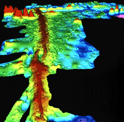
Computer-generated detailed topographic map of a segment of the Mid-Oceanic Ridge. "Warm" colors (yellow to red) indicate the ridge rising above the seafloor, and the "cool" colors (green to blue) represent lower elevations. This image (at latitude 9° north) is of a small part of the East Pacific Rise. (Imagery courtesy of Stacey Tighe, University of Rhode Island.)
File history
Click on a date/time to view the file as it appeared at that time.
| Date/Time | Thumbnail | Dimensions | User | Comment | |
|---|---|---|---|---|---|
| current | 01:35, 25 November 2005 | | 410 × 403 (55 KB) | Ashcraft (talk | contribs) | Source: USGS (public domain) http://pubs.usgs.gov/publications/text/topomap.html Computer-generated detailed topographic map of a segment of the Mid-Oceanic Ridge. "Warm" colors (yellow to red) indicate the ridge rising above the seafloor, and the "cool" |
You cannot overwrite this file.
File usage
The following file is a duplicate of this file (more details):
- File:Midoceanic ridge topography.gif from shared image pool
The following page uses this file: