File:Grizzly map.JPG
Grizzly_map.JPG (450 × 496 pixels, file size: 30 KB, MIME type: image/jpeg)
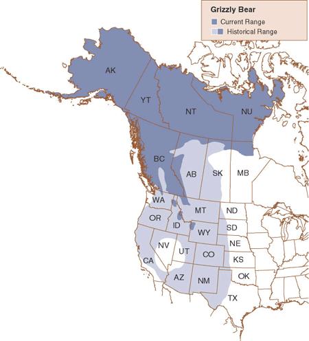
Map of the grizzly bear's current and historical range in North America.
From the "Environment Canada" website:
Non-commercial Reproduction Information on this site has been posted with the intent that it be readily available for personal and public non-commercial use. Unless otherwise noted by the application of the copyright symbol (Environment Canada, Date), materials on this site may be reproduced, in part or in whole and by any means, without charge or further permission from Environment Canada. We ask only that:
Users exercise due diligence in ensuring the accuracy of the materials reproduced; Environment Canada be identified as the source department; and, The reproduction is not represented as an official version of the materials reproduced, nor as having been made in affiliation with or with the endorsement of Environment Canada.
Source:Wikimedia Commons http://commons.wikimedia.org/wiki/Image:Grizzly_map.gif
File history
Click on a date/time to view the file as it appeared at that time.
| Date/Time | Thumbnail | Dimensions | User | Comment | |
|---|---|---|---|---|---|
| current | 04:34, 26 March 2006 | | 450 × 496 (30 KB) | Ashcraft (talk | contribs) | Map of the grizzly bear's current and historical range in North America. From the "Environment Canada" website: Non-commercial Reproduction Information on this site has been posted with the intent that it be readily available for personal and public non |
You cannot overwrite this file.
File usage
The following page uses this file: