De CriaçãoWiki, a enciclopédia da ciência da criação.
Saltar para a navegaçãoSaltar para a pesquisa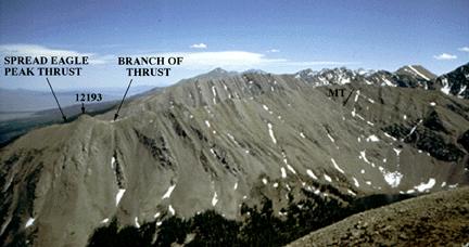
Sem resolução maior disponível.
Summary
Photograph of ridge south of Middle Taylor Creek, showing Spread Eagle Peak thrust and section of Minturn Formation. MT, main turbidite member.
The SPREAD EAGLE PEAK THRUST is exposed on peak 12,193, on the ridge south of Middle Taylor Creek (see attached map). The thrust dips steeply west here (more than 80 degrees), but is interpreted to flatten at depth. Throughout much of its extent, the thrust displays a bifurcating pattern. The thrust extends north and south for a total distance of more than 20 km, outlining a large thrust plate in folded Minturn and Sangre de Cristo Formations (structure section, Fig. 5). The front of the thrust plate is composed of an anticlinorium of Minturn Formation. The rear part of the plate, located west of the crest of the range, consists of a large syncline (Gibson Peak syncline) of Sangre de Cristo Formation. Rocks of the Spread Eagle Peak plate override tightly folded red sandstones of the Sangre de Cristo Formation, exposed east of peak 12193. Zircons from a light-colored felsic dike in the thrust south of peak 12193 have been dated as 26.5 +/- 1.1 Ma by the fission-track method by C. W. Naeser. The dike is unsheared and is interpreted to have been emplaced during Rio Grande rifting that formed the Wet Mountain Valley graben.
Copyright status
This image is public domain because it was first published by the U.S. Geological Survey.
Source
http://pubs.usgs.gov/of/2001/ofr-01-0249/TRIPLOG.HTM
Histórico do ficheiro
Clique uma data e hora para ver o ficheiro tal como ele se encontrava nessa altura.
| Data e hora | Miniatura | Dimensões | Utilizador | Comentário |
|---|
| atual | 20h08min de 1 de janeiro de 2007 |  | 432 × 228 (21 kB) | Ashcraft | Photograph of ridge south of Middle Taylor Creek, showing Spread Eagle Peak thrust and section of Minturn Formation. MT, main turbidite member. The SPREAD EAGLE PEAK THRUST is exposed on peak 12,193, on the ridge south of Middle Taylor Creek (see attach |
Utilização local do ficheiro
A seguinte página usa este ficheiro: