Ficheiro:Pacific Ring of Fire.png

Ficheiro original (1 024 × 760 píxeis, tamanho: 664 kB, tipo MIME: image/png)
Summary
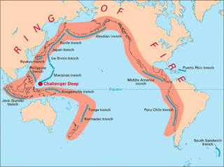
English: Volcanic arcs and oceanic trenches partly encircling the Pacific Basin form the so-called Pacific Ring of fire, a zone of frequent earthquakes and volcanic eruptions. The trenches are shown in blue-green. The volcanic island arcs, although not labelled, are parallel to, and always landward of, the trenches. For example, the island arc associated with the Aleutian Trench is represented by the long chain of volcanoes that make up the Aleutian Islands. Source: http://pubs.usgs.gov/publications/text/fire.html
Copyright status:
| This image is in the public domain because it contains materials that originally came from the United States Geological Survey, an agency of the United States Department of the Interior. For more information, see the official USGS copyright policy. |
Source:
http://commons.wikimedia.org/wiki/File:Pacific_Ring_of_Fire.png
Histórico do ficheiro
Clique uma data e hora para ver o ficheiro tal como ele se encontrava nessa altura.
| Data e hora | Miniatura | Dimensões | Utilizador | Comentário | |
|---|---|---|---|---|---|
| atual | 15h24min de 16 de outubro de 2013 | | 1 024 × 760 (664 kB) | Luiz Alexandre Silva | English: Volcanic arcs and oceanic trenches partly encircling the Pacific Basin form the so-called Pacific Ring of fire, a zone of frequent earthquakes and volcanic eruptions. The trenches are shown in blue-green. The volcanic island arcs, although not la |
Utilização local do ficheiro
A seguinte página usa este ficheiro: